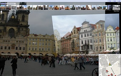
Google has finally opened up their geo-tagged photo source for Maps and Street Views from the irritating and cumbersome Panaramio to Flickr and Picasa. (official Google Release). Geo-tagged photos are tagged by you (automatically or manually) with the location of a photo. Google takes that data and situates the photo on Google Maps and Google Street Maps with a link back to its source (in this case Flickr) where your flickr profile is set up with photos of your community, local architecture, etc.
Why is this good for real estate you ask?
- Google still spanks Bing when it comes to maps and street views (although for how long is anyone’s guess since Bing has really upped their game as of late). Most consumers go straight to Google for their mapping needs and use Street Views to check out communities and streets before going to look at specific homes. (Bing already uses Flickr on their Street Views, so Flickr geo-tagged photos you are on the two most used street view map sites)
- Many Realtors use Flickr as their predominant photo sharing site for their communities and listings
- Combine 1 (consumers) + 2 (Realtors) in one place = Great Brand Building and Exposure as the Realtor for the Community
Geo-tagging photos can be accomplished in several ways:
- Use a camera with GPS (like the Nikon Coolpix P6000)
- Install a card with GPS into a non-GPS Camera (like Eye-Fi)
- Geo-tag them in your photo software (like iPhoto)
- Geo-tag them on your photo sharing site (like Flickr)
The small added effort can result in a added layer of presence in your community and now on Google Street Views and Maps. Our Geo-Tagged Flickr Map.